
Durango Bill’s
Ancestral Rivers of the World
Ancestral Rivers
in Africa
by
Bill Butler
by
Bill Butler
Antecedence and superimposition are geologic processes that explain how and why rivers can cut through mountain systems instead of going around them. The examples here (including pictures) are from Africa, but other examples can be found throughout the world.
Featured areas
Arroyos (“intermittent rivers”), Algeria
Blue Nile (Abay River), Ethiopia
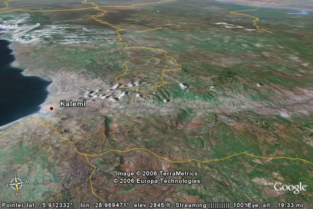
Congo River, Democratic Republic of the Congo and the Republic of the Congo
Lufira River, Upemba Natl. Park, Democratic Republic of the Congo
Lukuga River, Lake Tanganyika, Democratic Republic of the Congo
Luvua River, Lake Mweru, Democratic Republic of the Congo & Zambia
Meiringspoort Gorge, Groot River, South Africa
Nile River, Sixth Cataract, Sabaloka Gorge, Sudan
Zambezi River, Kariba Dam/Reservoir, Zambia & Zimbabwe
Arroyos
(“intermittent rivers”), Algeria
We think of a river as something that has water all the time. In some places in the world, a “river” only has water on the rare occasions when it rains. The rest of the time the “river” is a dry arroyo.
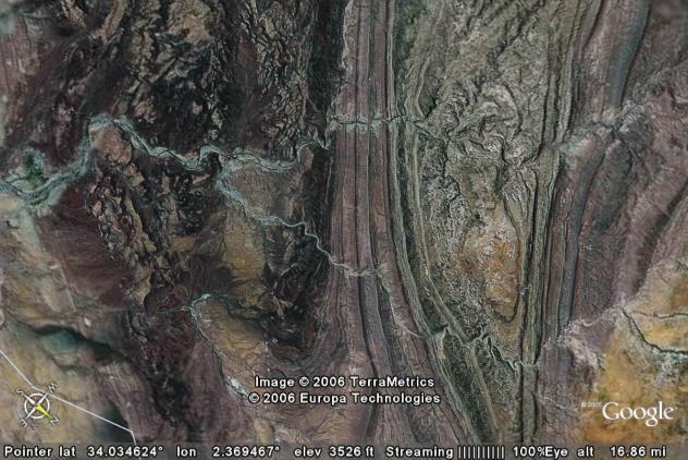
The picture above is a vertical view of typical arroyos in the Sahara Desert, some 30 miles west-northwest of Laghouat, Algeria. The arroyos are cutting across folded sedimentary layers. The harder sedimentary layers are more resistant to erosion, and where they are tilted upward, they form hogback ridges. When it does rain, the muddy run-off water is quite capable of ordinary river erosion and has cut short canyons through these ridges. The deepest of these canyons are found in the dark ridge in the center of the picture, and are up to 800 feet deep.
The drainage pattern for the arroyos was probably established some 10 million years ago across a beveled surface and before more recent uplifts. (This is a “very fuzzy” estimate.) More recently, the general area has been uplifted and erosion has set in again. When it does rain, softer surface material is washed away, and the old more resistant ridges are left intact.
The sedimentary layers themselves are of interest. 100 to 200 million years ago, this area was the bottom of a shallow sea. Silt, mud, algae, the remains of other organic material, etc. settled out on the bottom of this ancestral sea. These accumulated into multiple layers totaling several thousands of feet thick. These sediment accumulation areas extended well to the southeast of the area in the picture. With time, these sediments were buried deep enough to cook the organic remains into oil.
Beginning about 50 million years ago (again “very fuzzy”) the area in the picture was crumpled into anticlines and synclines. Erosion beveled these earlier mountains to an essentially flat surface. The current arroyo drainage systems were established across this beveled surface. The drainage patterns are thus an example of superimposition.
Finally, renewed recent uplift has allowed erosion to set in again. The entire surface has been eroded down from the earlier flat surface. The greatest surface erosion has taken place in the “softer” layers while the more resistant layers have been exposed as “hogback” ridges. The arroyos were able to erode down through these more resistant ridges, and thus they have been able to maintain their paths.
Blue Nile River
(Abay River), Ethiopia
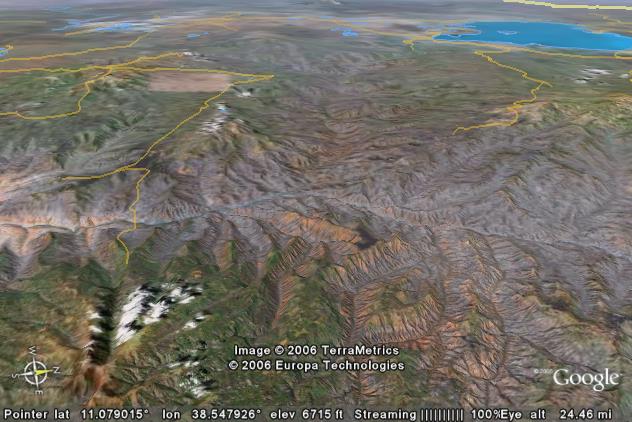
The picture above shows the origin of the Blue Nile (Abay) River in Ethiopia. The river originates in Lake Tana (Tana Hayk) which can be seen in the upper right corner of the picture. The elevation of the lake is about 5,865 feet above sea level.
After the river leaves the lake it flows southeastward to about the center of the picture and then turns more to the south where it cuts through the Choke Mountains. It leaves the field of view just below the center of the left edge.
The mountains on both side of the gorge are more than 11,000 feet high. The river leaves the lake at about 5,865 feet, and is down to below 4,000 feet in-between these high peaks.
This part of Ethiopia is on the northwest side of the African rift zone. The rifts themselves are off the lower edge of the picture, but uplift just to the northwest of the rift is producing the mountains in the foreground portion of the picture.
Uplift is much greater in the foreground and much less in the distant portion of the picture. The result is a “tipping” of the terrain.
The Blue Nile River was in place before this uplift/tipping began. The first effect of the uplift was to dam the river. The initial Lake Tana was closer to the foreground. As the mountains rose the Blue Nile immediately began to erode into them as a natural process to try to maintain its path. The erosion process started to cut the gorge. Also the “tipping” process is causing the lake to migrate toward the northwest. (Toward the distance in this view.)
While you can’t see it in this view, a closer Google Earth view of the southeast side (near side) of the lake shows ancestral beach terraces extending up to 8 miles inland from the current lake shore. As the lake slowly tips down toward the northwest, these ancestral beaches are left behind.
Lake Tana is destined to disappear in a few million years. If erosion by the Blue Nile is strong enough to offset the tipping, the gorge will eventually cut back upstream into the lake and thus drain it. If this “headstream erosion” doesn’t destroy the lake, the tipping will.
Tipping is forcing the lake to migrate northwestward. However, this motion is driving the northwest shore of the lake ever closer to the rim of the plateau, and there is a steep downhill gradient on the far side of this rim. The lake level is within 300 vertical feet of this rim on the lake’s west side, and if/when the rim is breached, the river can easily rip out a new path to the west. When that happens, the current Blue Nile River will be history, and there will only be local drainage left in the canyon that we see in the picture.
Congo River,
Democratic Republic of the Congo and the Republic of the Congo
In terms of water volume, the Congo River is the second biggest river in the world. (First place goes to the Amazon River). In this picture it forms the border between the Democratic Republic of the Congo (right side of the river) and the Republic of the Congo (left side of the river). The respective capitals of Kinshasa and Brazzaville are about 35 linear miles downstream off the lower edge of the picture.
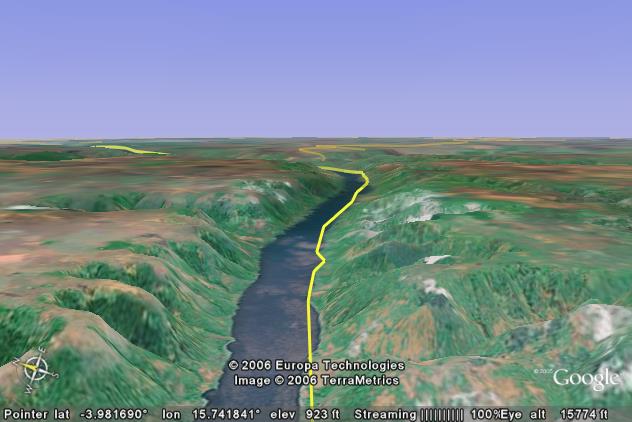
In the picture we can see that the Congo has cut a narrow gorge down through a very flat plateau. Elevations of the top of the plateau range from 2,150 to 2,250 feet above sea level while the river is about 850 feet above sea level.
If we measure the narrowest rim-to-rim width (elevations greater than 2,150 feet above sea level), the gorge is only 3 miles wide. What is interesting is the huge upstream area that is lower than the 2,150-foot rim. If you built a rim-to-rim dam across the gorge, you would flood many hundreds of thousands of square miles upstream. The lake would back up over 1,000 miles. It would cover an area several times larger than the combined 5 Great Lakes. There are several possible alternate exit elevations below 2,000 feet including an approximate 1,700-foot possible exit that would overflow to the north to inundate Lake Chad on the southern edge of the Sahara Desert.
The Congo River was here long before the plateau was uplifted. The elevation of the river has been below 1,000 feet above sea level for many tens of millions of years. The Congo Gorge is relatively narrow which indicates it has been cut recently. The plateau has been uplifted over the last ten million years. As the plateau rose, the Congo River was quite capable of eroding away material that kept trying to get in the way.
Lufira River,
Upemba Natl. Park, Democratic Republic of the Congo
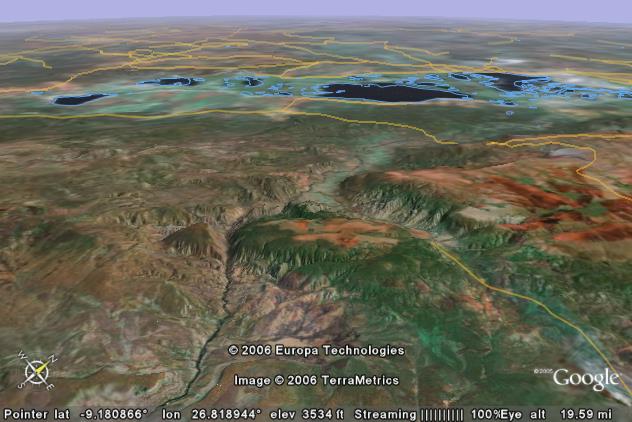
The picture above looks northwestward across a plateau in Upemba National Park in the southern portion of the Democratic Republic of the Congo. The largest of the distant lakes is Lake Upemba.
The Lufira River enters the picture from the lower left edge and cuts across the middle of a long northeast to southwest plateau that extends 75 miles to the right and 100 miles to the left of the deep gorge. The top of the plateau is uniformly between 5,000 and 6,000 feet above sea level while the river in the bottom of the gorge is about 2,500 feet. Thus the short, sharp canyon is over half a mile deep.
Uplift history of the area is not known. The area is not too far west of the African Rift Zone, and recent uplift may be related to the rift. However the steep sides of the canyon indicate that it has been cut from scratch in the last 10 million years. In any case the implication is that the river was in place first, and as the area was uplifted, the river eroded away a rising mountain mass that kept trying to get in the way.
There are two adjacent indentations in the plateau that are of interest. One is a short distance to the left of the gorge while the second one is further to the right. Both of these indentations in the plateau look like they were formerly tributary systems to the Lufira River. As the plateau rose neither one of these tributaries had the erosion power of the Lufira. Both of these former tributary systems cut down a short distance into the rising plateau, and then rerouted to join the Lufira off the lower left edge of the picture before the Lufira cuts across the plateau. Basically it was easier to let “The Big Guy” do the erosion work.
Lukuga River,
Lake Tanganyika, Democratic Republic of the Congo
The picture above looks south over the western edge of Lake Tanganyika and the Lukuga River in the southeastern part of the Democratic Republic of the Congo. The Lukuga River is the outlet for Lake Tanganyika (left edge), and the river flows across the center of the field of view to exit off the middle of the right edge. In the process, the river cuts through a broad area of mountains and plateaus (in the center of the picture) that are 1,500 to 2,000 feet higher than Lake Tanganyika.
Lake Tanganyika is “a work in progress”. Convection currents in the earth’s mantle are beginning to raft a large portion of eastern Africa away from the rest of the continent. A “rift” is developing between the two sections. Bedrock directly in the rift is being faulted downward in an attempt to fill in the rift. The technical name for this type of structure is a “graben”. Run-off water from ordinary rain plus accompanying silt drain into this widening rift, but the rift is continuing to get wider and deeper. Lake Tanganyika is nearly 5,000 feet deep. It is the second deepest and second most voluminous lake in the world. Lake Baikal in Russia, another rift lake, is first in both categories. If the rifting process continues for a few more tens of millions of years, eastern Africa will move away from the rest of Africa, and a new ocean will fill the gap.
The earth’s crust is floating on top of the mantle. For any given area, the weight of the crust pushing down is exactly offset by the upward pressure in the mantle that is holding the crust up. If you decrease the weight over a given area by any process, then the two forces will become unbalanced, and the mantle will lift the whole region back up again until the forces are once again in equilibrium.
The rifting that has opened up the earth’s crust has reduced the total net weight of the crust in the vicinity of Lake Tanganyika. When the forces in the earth’s mantle lift the crust to reestablish equilibrium, the areas adjacent to Lake Tanganyika are included. This lifting produces new mountain ranges adjacent to the lake including the area seen in the picture.
The ancestral Lukuga River was in place before the mountains near the lake began to rise. As the mountains were uplifted, ordinary erosion by the river removed material that kept trying to get in the way. Today we see the result of this erosion. The Lukuga River has cut a gorge through the rising mountain range.
Luvua River, Lake
Mweru, Democratic Republic of the Congo & Zambia
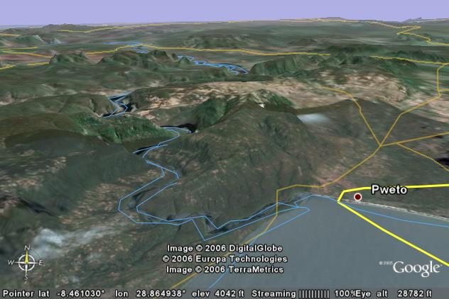
The view above extends from the north end of Lake Mweru northward over the southeastern corner of the Democratic Republic of the Congo. A small piece of Zambia is included in the lower right corner. The Luvua River is the outlet for the lake and immediately cuts into 4,600+ foot high mountains on the left side of the picture. There are multiple other exit possibilities for the lake that stay under 3,600 feet. The lake itself is just over 3,000 feet.
Lake Mweru and the Luvua River are part of the African rift system. Lake Tanganyika (see above) is only about 105 miles to the northeast.
Uplift history of the 4,600-foot mountains on the left side of the picture is not known. A speculative analysis implies the mountains are bounded by one fault that forms the left lakeshore and two nearly parallel faults on the far side of the mountains. It appears the uplift has taken place in the last 20 million years.
In any case, this looks like another example of antecedence. The river was in place first, and as the mountains rose, the river was able to erode away rising material that kept trying to get in the way.
Meiringspoort
Gorge, Groot River, South Africa
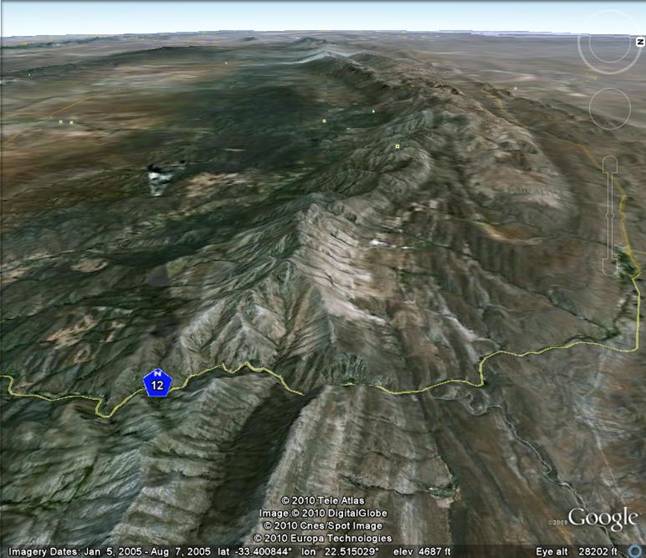
The view above looks west across South Africa’s Swartberg Mountains. There are several east to west mountain ranges in South Africa that are “in the way” of river systems that flow from north to south. The Groot River is just one of these, but nevertheless, it cuts through the mountain range instead of going someplace else. The Groot flows from north to south (right to left in the picture) to produce the spectacular 2,000+ foot deep Meiringspoort Gorge in the foreground.
The Gamka River also cuts through the Swartberg Mountains some 50+ miles further to the west. (Near the “hazy” area in the far distance.) A hydroelectric dam (the Gamkapoort Dam) has been built at the entrance to its gorge.
The rock layers in the mountain range are mostly folded Table Mountain Sandstone, but there are other sedimentary layers mixed in. The Cango Caves are in Precambrian limestone layers not too far from the gorge.
There have been several periods of uplift and folding of the Swartberg Mountains over the last 250 million years. The Groot (and other) River systems had established their north to south paths before the most recent uplift/folding period. As the mountains were uplifted, the Groot had enough erosive ability to cut down through the rising mountain range as rapidly as the mountain range was rising. Thus the Groot was ability to maintain its former path. The result of this cutting action is the Meiringspoort Gorge.
The name “Meiringspoort”, (literally - Meiring’s gate) originally was derived from a Petrus Johannes Meiring who settled on the south side of the Swartberg Mountains nearly 200 years ago. Out of curiosity he followed the river upstream to see where it came from. In the process, he discovered the gorge.
Nile River, Sixth
Cataract, Sabaloka Gorge, Sudan
The picture above looks northeastward where the Nile River cuts through the Sabaloka Mountains to form Sabaloka Gorge. Sabaloka Gorge is some 50 miles north of Khartoum, Sudan, in the southeastern corner of the Sahara Desert. The mountains are a dark complex of hard, old, mostly volcanic rock that contrasts with the lighter color sands of the Sahara Desert.
The Sabaloka Mountains form a small plateau some 5 to 6 miles wide and about 8 miles long. The central plateau of the mountains averages about 1,700 feet above sea level. The Nile River here is about 1,200 feet above sea level. Thus the gorge is about 500 feet deep.
There are easier paths for the Nile around both sides of the mountains where the terrain stays under 1,350 feet. Why did the Nile pick a path through the Sabaloka Mountains?
Again we have a textbook example of antecedence. The Nile was here before the mountains existed. The mountains were subsequently formed when “recent” (probably within the last 20 million years) intrusions of magma (molten igneous rock) pushed upward and then sideways through subterranean layers of bedrock. The surface layers were uplifted by the magma intrusions. (The process is similar to how a blood blister is formed when you break a blood vessel under your skin.) The “buzzword” name for this particular geologic feature is the Sabaloka Pluton.
The Nile River was able to erode downward as the mountains were uplifted. Thus it maintained its original course. A better description might be that the Nile River stayed put while the block of rock that became the mountains was uplifted. All the Nile had to do was to erode away the rock layers that were being uplifted into its path.
The hard rock of the Sabaloka Mountains has been quarried as a source for stone tools since earliest Egyptian history. As such it has become an area of interest for archeologists in recent years. For example, please see: link
Zambezi River,
Kariba Dam/Reservoir, Zambia & Zimbabwe
The picture below overlooks the Kariba Dam/Reservoir on the Zambezi River. The Zambezi River forms the border between Zambia on the left and Zimbabwe on the right. The gorge through the mountains was an ideal place to build one of the largest hydroelectric projects in Africa. The downside was that many tens of thousands of people were displaced by the resulting reservoir, and left to fend for themselves in what has been described as “the worst dam-resettlement disaster in African history.”
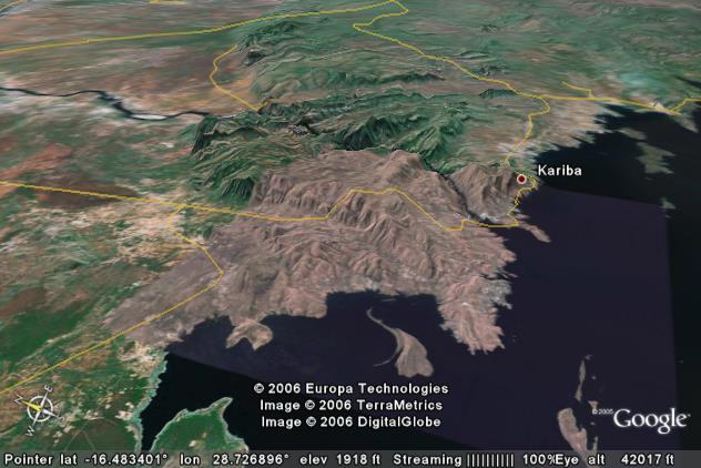
The picture above shows where the Zambezi River has cut a 1,500-foot deep gorge through the uplifted mountains/plateau in the center portion of the picture. There is a much easier, 900-foot lower alternate path (near the left edge) that logically, the river should have taken. Why does the river flow through today’s high elevations when a low elevation path is available?
The Zambezi established is path when the lowest available path was its current path. The mountains/plateau had not been uplifted yet. If you look at the picture, you can see a sharp boundary between the highlands in the top center portion of the picture and the lowlands in the upper left corner. The boundary is an obvious fault system.
Over the last 10 to 20 million years, the land to the right of the fault has been lifted upward. If the Zambezi had not been able to erode down through the rising land mass, it would have been dammed and would have been forced to take the left hand route. However, the erosion ability of the Zambezi was equal to the task. As the land mass rose, the Zambezi abraded away material that kept trying to get in the way.
Return to main Ancestral Rivers Page
Web page generated via Sea Monkey's Composer
within a Linux Cinnamon Mint 18 operating system.
(Goodbye Microsoft)