Durango Bill's
Grand Canyon 3-D Tour
3-D Geologic Tour of the Grand Canyon
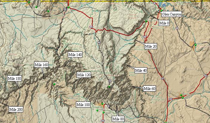
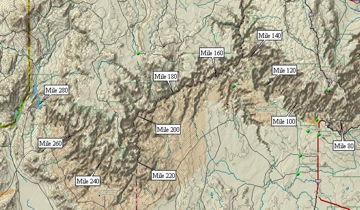
Pictures cover the entire 280 miles of the Grand Canyon
(Pictures are computer generated images)
The
links below give an end-to-end aerial geologic tour of the
Colorado River in the Grand Canyon. Sequencing through them
simulates a nearly 300-mile trip starting with Glen Canyon
Dam at Page, AZ, and continuing past the Grand Wash Cliffs
to Lake Mead.
All 3-D pictures were generated with DeLorme's Topo USA version 3.0 program. Each picture used:
Zoom = 12
Magnification = 50%
Vertical Exaggeration = 1
Pitch = 30 deg.
Thus, all pictures use a standard field of view. Contour intervals are 50 feet for all pictures.
Also, please see Origin of the Grand Canyon
Grand Canyon Maps
and Recommended Grand Canyon Videos
Return to Durango Bill's home page

(Please allow a few seconds to download each page as they contain pictures)
All 3-D pictures were generated with DeLorme's Topo USA version 3.0 program. Each picture used:
Zoom = 12
Magnification = 50%
Vertical Exaggeration = 1
Pitch = 30 deg.
Thus, all pictures use a standard field of view. Contour intervals are 50 feet for all pictures.
Also, please see Origin of the Grand Canyon
Grand Canyon Maps
and Recommended Grand Canyon Videos
Return to Durango Bill's home page
3-D Grand
Canyon Tour

(Please allow a few seconds to download each page as they contain pictures)
Glen Canyon - Page, AZ to Lees Ferry.
About 15.5 river miles
Grand Canyon - River Miles 0 to 8 Lees Ferry to Badger Creek
Grand Canyon - River Miles 8 to 16 Badger Creek to Rider Canyon
Grand Canyon - River Miles 16 to 24 Rider Canyon to the Roaring Twenties Rapids
Grand Canyon - River Miles 24 to 32 Roaring Twenties Rapids to South Canyon
Grand Canyon - River Miles 32 to 40 South Canyon to Buck Farm Canyon
Grand Canyon - River Miles 40 to 48 Buck Farm Canyon to Saddle Canyon
Grand Canyon - River Miles 48 to 56 Saddle Canyon to Kwagunt Creek
Grand Canyon - River Miles 56 to 64 Kwagunt Creek to Little Colorado River to Temple Butte
Grand Canyon - River Miles 64 to 72 Temple Butte to Unkar Creek
Grand Canyon - River Miles 72 to 80 Unkar Creek to Hance Rapid to Cottonwood Creek
Grand Canyon - River Miles 80 to 88 Cottonwood Creek to Phantom Ranch/Bright Angel Canyon
Grand Canyon - River Miles 88 to 96 Phantom Ranch to Boucher Creek
Grand Canyon - River Miles 96 to 104 Boucher Creek to Crystal Rapid to Ruby Canyon
Grand Canyon - River Miles 104 to 112 Ruby Canyon to Walthenberg Canyon
Grand Canyon - River Miles 112 to 120 Walthenberg Canyon to Elves Chasm to Blacktail Canyon
Grand Canyon - River Miles 120 to 128 Blacktail Canyon to 128 Mile Canyon
Grand Canyon - River Miles 128 to 136 128 Mile Canyon to Deer Creek Falls
Grand Canyon - River Miles 136 to 144 Deer Creek Falls to Kanab Creek
Grand Canyon - River Miles 144 to 152 Kanab Creek to Boysag Point
Grand Canyon - River Miles 152 to 160 Boysag Point to Havasu Creek and S B Point

Grand Canyon - River Miles 120 to
128 Blacktail
Canyon to 128 Mile Canyon
Grand Canyon - River Miles 128 to 136 128 Mile Canyon to Deer Creek Falls
Grand Canyon - River Miles 136 to 144 Deer Creek Falls to Kanab Creek
Grand Canyon - River Miles 144 to 152 Kanab Creek to Boysag Point
Grand Canyon - River Miles 152 to 160 Boysag Point to Havasu Creek and S B Point
Grand Canyon - River Miles 160 to 168 S B Point to National Canyon to Fern Glen Canyon
Grand Canyon - River Miles 168 to 176 Fern Glen Canyon to Toroweap Point
Grand Canyon - River Miles 176 to 184 Toroweap Point to Lava Falls Rapid and Mile 184
Grand Canyon - River Miles 184 to 192 Mile 184 to the Hurricane Fault at 192 Mile Canyon
Grand Canyon - River Miles 192 to 200 Hurricane Fault at 192 Mile Canyon to Mollies Nipple
Grand Canyon - River Miles 200 to 208 Mollies Nipple to Granite Park
Grand Canyon - River Miles 208 to 216 Granite Park to start of Lower Granite Gorge
Grand Canyon - River Miles 216 to 224 Start of Lower Granite Gorge to Diamond Peak
Grand Canyon - River Miles 224 to 232 Diamond Peak to River Mile 232
Grand Canyon - River Miles 232 to 240 River Mile 232 to Separation Canyon
Grand Canyon - River Miles 240 to 248 Separation Canyon to Surprise Canyon (& Separation Rapid)
Grand Canyon - River Miles 248 to 256 Surprise Canyon to Salt Creek
Grand Canyon - River Miles 256 to 264 Salt Creek to Tincanebitts Canyon
Grand Canyon - River Miles 264 to 272 Tincanebitts Canyon to River Mile 272
Grand Canyon - River Miles 272 to 280 River Mile 272 to the Grand Wash Cliffs and Lake Mead
Grand Canyon - Superimposition Rapid A new major rapid is expected to form near River Mile 280
Grand Canyon - Lower Superimposition Rapid Still another major rapid is expected to form - this one near River Mile 286
Web page generated via Sea Monkey's Composer HTML editor
within a Linux Cinnamon Mint 18 operating system.
(Goodbye Microsoft)