Durango Bill's
Paleogeography (Historical Geology) Research
Formation and Origin of
Canyon of Lodore, Colorado and Split Mountain, Utah
The origin and formation of Split Mountain and the Canyon of Lodore
with 3-D computer generated pictures

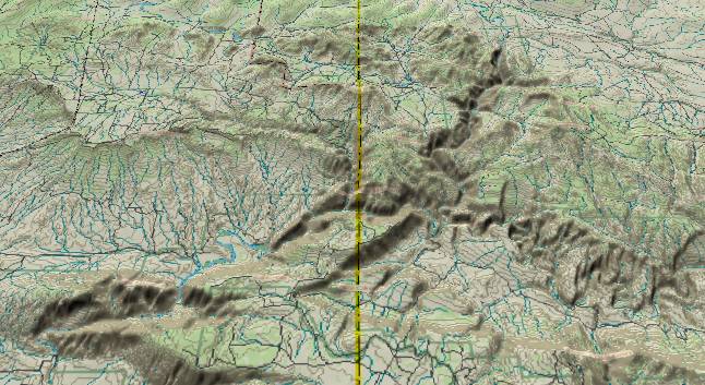
Contour lines at
100-foot intervals. The Green River cuts NNE to SSW through
the southeast end of the Uinta Mountains to form the Canyon of
Lodore (to the right of center). The Green River also cuts
through Split Mountain (Lower left corner of the picture)
instead of going around it to create another of the paradoxes
frequently found in the southwestern U. S. The largest
tributary to the Green River is the Yampa, which enters from
the lower right edge and joins the Green in Dinosaur National
Monument. Before the recent renewed uplift of the highlands,
tributary streams entered the Yampa from the south. Turner
Creek is a remnant of these and cuts south to north through
the highlands near the lower edge. (About 40% of the way from
the state line to the right edge.)

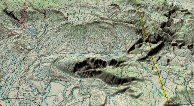
Detail of Split
Mountain. Contour lines at 100-foot intervals. Diamond
Mountain (top) and Blue Mountain Plateau (lower right) are
remnants of the floor of the flat valley that existed before
the Colorado River changed its course to cross the Kaibab
Plateau. As the Grand Canyon was cut, the exit elevation for
the entire basin was lowered. The Yampa/Green River was over
the top of Split Mountain when it became entrenched, and then
just cut down through it. Meanwhile ordinary erosion has
removed softer Tertiary and Cretaceous sediments on the north,
west, and south sides of the mountain.
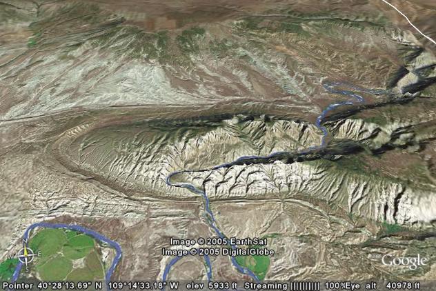
The 3-D view above was generated via Delorme’s Topo USA program. Google’s “Google Earth” program can also generate 3-D views (below). The Google Earth program doesn’t show contour lines, but can generate near photographic images of any location in the world. In this Google version note the “hogback ridges” that flank Split Mountain. The hogback ridges are eroded remnants of Mesozoic Era sedimentary layers with the famous quarry in Dinosaur National Monument located at short distance to the left of where the Green River emerges from Split Mountain.

During the late Cretaceous and early Tertiary, river drainage in this area was southwest to northeast, which is opposite the current direction. Rivers brought in massive amounts of silt from the southwest and buried the area from northeast Utah across Wyoming. Areas to the south of Split Mountain were also buried.
Around 20 to 25 million years ago, uplifts across southern Wyoming and northern Colorado blocked river exit routes out through Wyoming and rivers found new routes flowing toward the west. The Yampa River developed at this time and continued out of the picture toward the southwest.
About mid Miocene time there was a renewed uplift of the Wind River Range in Wyoming. Drainage that had been flowing northeastward out of the Green River Basin reorganized to form the current Green River. This early version of the Green flowed southeast to join the Yampa with the juncture probably off the right edge of the top picture.
By about 15 million years ago most of the Dinosaur highlands had eroded down to a near featureless plain that merged with silt filled lowlands to the south, east, and north. There was little vertical relief across the entire area, and thus everything was ready to be buried when the Browns Park silt would be deposited.
During the Miocene, the Wasatch Ranges in Utah were rising, and by 10 million years ago started to block the ancestral Colorado's westward exit route into the Utah deserts. Every time the Wasatch would rise a little, everything to the east would back up a little more. By the breakpoint time of 5.4 million years ago, this backup system reached into northwestern Colorado. The Green and Yampa Rivers brought in a lot of silt that buried everything in the area. This silt would become the Browns Park Formation. (Browns Park is the NW to SE valley in the upper right of the top picture.)
At or shortly after the breakpoint, the two rivers established their current paths across the silt flats. Then they started cutting downward. Finally, the eastern Uintas and Dinosaur highlands have risen about 1,500 feet in the last 5 million years. Just by chance the Green River happened to end up over the top of Split Mountain. By the time it had eroded down to it, the Green was entrenched and couldn't change course. Finally, recent erosion has removed softer deposits around the old mountain.
Also please see Harpers Corner and the Bishop Conglomerate.
Return to the Image Index Page
Web page generated via Sea Monkey's Composer HTML editor
within a Linux Cinnamon Mint 18 operating system.
(Goodbye Microsoft)
The 3-D view above was generated via Delorme’s Topo USA program. Google’s “Google Earth” program can also generate 3-D views (below). The Google Earth program doesn’t show contour lines, but can generate near photographic images of any location in the world. In this Google version note the “hogback ridges” that flank Split Mountain. The hogback ridges are eroded remnants of Mesozoic Era sedimentary layers with the famous quarry in Dinosaur National Monument located at short distance to the left of where the Green River emerges from Split Mountain.

During the late Cretaceous and early Tertiary, river drainage in this area was southwest to northeast, which is opposite the current direction. Rivers brought in massive amounts of silt from the southwest and buried the area from northeast Utah across Wyoming. Areas to the south of Split Mountain were also buried.
Around 20 to 25 million years ago, uplifts across southern Wyoming and northern Colorado blocked river exit routes out through Wyoming and rivers found new routes flowing toward the west. The Yampa River developed at this time and continued out of the picture toward the southwest.
About mid Miocene time there was a renewed uplift of the Wind River Range in Wyoming. Drainage that had been flowing northeastward out of the Green River Basin reorganized to form the current Green River. This early version of the Green flowed southeast to join the Yampa with the juncture probably off the right edge of the top picture.
By about 15 million years ago most of the Dinosaur highlands had eroded down to a near featureless plain that merged with silt filled lowlands to the south, east, and north. There was little vertical relief across the entire area, and thus everything was ready to be buried when the Browns Park silt would be deposited.
During the Miocene, the Wasatch Ranges in Utah were rising, and by 10 million years ago started to block the ancestral Colorado's westward exit route into the Utah deserts. Every time the Wasatch would rise a little, everything to the east would back up a little more. By the breakpoint time of 5.4 million years ago, this backup system reached into northwestern Colorado. The Green and Yampa Rivers brought in a lot of silt that buried everything in the area. This silt would become the Browns Park Formation. (Browns Park is the NW to SE valley in the upper right of the top picture.)
At or shortly after the breakpoint, the two rivers established their current paths across the silt flats. Then they started cutting downward. Finally, the eastern Uintas and Dinosaur highlands have risen about 1,500 feet in the last 5 million years. Just by chance the Green River happened to end up over the top of Split Mountain. By the time it had eroded down to it, the Green was entrenched and couldn't change course. Finally, recent erosion has removed softer deposits around the old mountain.
Also please see Harpers Corner and the Bishop Conglomerate.
Return to the Image Index Page
Web page generated via Sea Monkey's Composer HTML editor
within a Linux Cinnamon Mint 18 operating system.
(Goodbye Microsoft)