Durango Bill’s
Colorado Geology
Rockfall/rockslide
in
the Rio Chama Headwaters
A large rockfall occurred in a remote area of the upper Rio Chama headwaters sometime between Sept. 1998 and June 2005. There appears to be no available information about the rockfall, and the author happened to find it while browsing with Google Earth.
The two Google Earth pictures below show the area before and after the rockfall. The rockfall itself is in Colorado’s southern San Juan Mountains about 14 miles north of Chama, NM. (Rockfall is at Lat. 37.11 N Long. 106.59 W) The rockfall/landslide fell about 1,400 vertical feet, and the runout covered a little over half a mile.
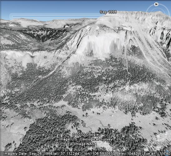
The picture above is a Google Earth view that looks north over the West Fork of the Rio Chama as of Sept. 26, 1998.
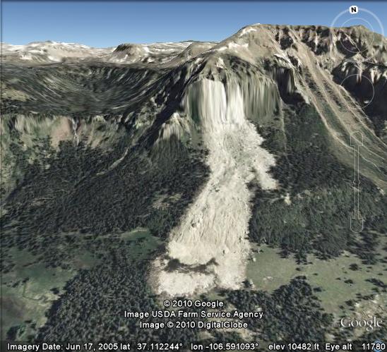
The picture above shows the same area, but seven years later in 2005. In the interim, a large block of rock broke loose from the cliffs and avalanched down through the forest below. It appears that the rockfall took place sometime between Sept. 29, 2003 and June 3, 2004. (See NASA photos further down the page.)
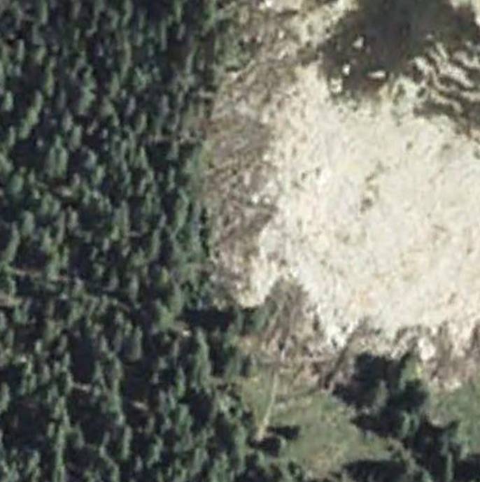
The picture above (via Google Earth) gives a close-up view of the toe of the rockfall/rockslide up against the edge of the undamaged forest. As the rockslide plowed into the forest, it snapped off trees at their base. The momentum of the rockslide would shove the base of a tree forward while the rest of the tree would topple backward onto the rock rubble. Some of the broken trees appear to have been carried several hundred feet from their original position.
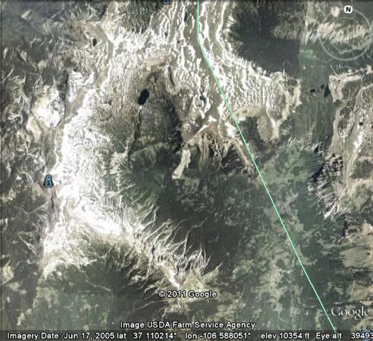
The picture above is another Google Earth view that looks straight down at the rockfall/rockslide. The green line is the boundary between Archuleta County to the left (west) and Conejos County to the right (east). The east to west field of view is about 6 miles.
NASA photos
confine time of the Rockfall
The two photos below are from NASA’s Visible Earth website and confine the timing of the rockfall to sometime between Sept. 29, 2003 and June 3, 2004.
For location purposes, in the above Google Earth picture, note that the rockfall is on the north side of the valley of the West Fork of the Rio Chama. The mountains surrounding the valley have a horseshoe shape – open to the southeast. This same dark green, horseshoe shaped valley appears in the center of both of the NASA pictures below. (The arrows point toward the dark green valley.) The east to west field-of-view in both pictures is about 106 miles.
The first NASA picture (below) has pretty good resolution with no sign of the rockfall as of Sept. 29, 2003. If the rockfall had taken place by Sept. 2003, the picture would show a gray blotch in the western end of the valley.
Original picture accessible at: http://visibleearth.nasa.gov/view_rec.php?id=5885
High resolution at: http://eoimages.gsfc.nasa.gov/ve/5885/Utah.A2003271.1810.250m.jpg


The resolution in this 2nd NASA picture is not as good, but if you look closely, there is a faint light gray streak in the western (left) end of the valley. By itself, the picture isn’t clear enough for definite confirmation. However, the picture by “nmnc” as of August 2004 (see below) does indicate that the rockfall occurred before Aug, 2004.
NASA picture date: June 3, 2004
Original picture accessible at: http://visibleearth.nasa.gov/view_rec.php?id=6889
High resolution at: http://eoimages.gsfc.nasa.gov/ve/6889/UnitedStates.A2004152.1740.250m.jpg
Note: the horizontal line in both NASA pictures is the Colorado/New Mexico border.
A third NASA picture as of Nov. 19, 2003 is accessible at http://visibleearth.nasa.gov/view_rec.php?id=6104 (high resolution at http://eoimages.gsfc.nasa.gov/ve/6104/UnitedStates.A2003322.2020.250m.jpg ), but it is difficult to differentiate between winter snows and the possible rockfall/rockslide.
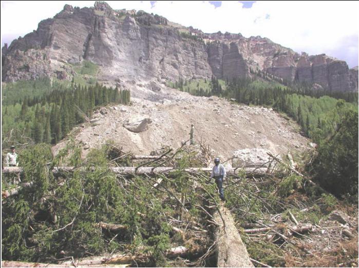
The photograph above was taken by John Rawinski, and published in the U. S. Forest Service’s:
Monitoring and Evaluation Report
FY 2004
Rio Grande National Forest, Colorado
http://www.fs.usda.gov/Internet/FSE_DOCUMENTS/stelprdb5181322.pdf
The USFS estimates that the rockfall/landslide occurred in the spring of 2004. The following description is included in the USFS report:
In June 2004, a trip was made into
the West Fork Rio Chama to investigate a new 40 acre landslide,
that originated under natural conditions. A huge block of
Conejos Formation conglomerate separated from a ledge and plowed
a ¼ strip in its path below. It cause a fish kill in the stream
killing Cuttthroat and Rainbow trout.
Topo USA Pictures
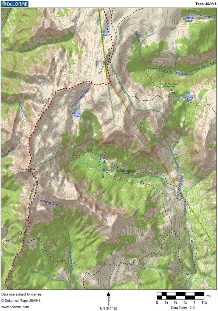
The next two pictures were generated by Delorme’s ( http://www.delorme.com/ ) Topo USA program. The first picture is a topographic map of the rockfall area.
(Click on the map for a larger, more detailed view)
The picture above is a topographic map of the rockfall area. The county line (mentioned previously) is on the right side of the picture while the red dashed line traces the Continental Divide Trail. The rockfall started when part of the cliff in the center of the picture broke loose with the resulting landslide wiping out the trees below the cliff. (The topo map shows the area before the rockfall – there’s no swath through the trees.) If you check the larger detailed map view, the lower end of the rockslide covers the “Rio Chama” portion of the “West Fork Rio Chama” label.
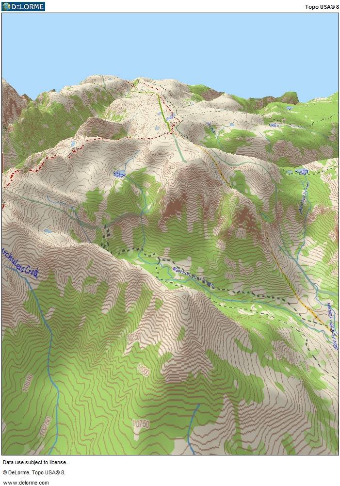
The picture above was also generated by Delorme’s Topo USA program and shows a 3D view of the area. The rockfall occurred on the steep cliff near the center of the picture.
Google Earth can also display photographs that have been uploaded. A photo taken by “nmnc” about Aug. 1, 2004 appears to show the rockfall. (See http://www.panoramio.com/photo/16408766 )
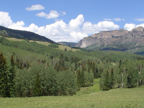
The photograph appears to have been taken some 3.2 miles SE of the rockfall, and looks toward the NW. The light gray streak on the mountain in the center distance is the rockfall.
Geology of the
Rockfall Area
The picture below is an excerpt from Ogden Tweto’s Geologic Map of Colorado. The printed version of the map is clearer, but a free online version can be downloaded from
http://geology.about.com/od/maps/ig/stategeomaps/COgeomap.htm
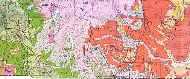
The rockfall covers the “T” of the “Tial” label just below the center of the picture.
Light purple areas (Tpl) on the map are 30 to 35 million-year-old “Pre ash flow andesitic lavas, breccias, tuffs and conglomerates”. In the Google Earth pictures, this layer includes the cliff. The “Tpl” layer is capped by the younger, red “Taf” layer which is more ash-flow tuff, but only 26 to 30 million years old. The “Tial” label points to “intra-ash flow andesitic lavas” which cap the ridge to the southwest of the valley. (Not visible in the first two Google Earth pictures.)
After the volcanic layers were uplifted to approximately their present elevation, the area was heavily glaciated over the last 2 million years. Glaciers typically carve out “U” shaped valleys with steep sides. Glacial erosion at the base of these steep sides can over-steepen them to the point where they are unstable.
As the glacial ice melted away, it left rock rubble in its wake. Also, the unstable, overly steepened sides occasionally collapse – as seen in the Google Earth pictures. Other nearby Google Earth views show the remains of other rockfalls/landslides beside the one highlighted in the pictures.
The last geological unit of interest (as depicted in the geological map) is the stippled light blue “Ql” zone that appears in the valley underneath the “Tial” label. The “Q” stands for Quaternary (recent) age. The “l’ as you might guess, indicates “Landslide deposits”.
Also of geological/glaciology interest, please see:
The Taku Glacier
What it is and what is going to happen to it
http://www.durangobill.com/TakuGlacier/TakuGlacier.html
Return to Durango Bill's Home page
Web page generated via Sea Monkey's Composer HTML editor
within a Linux Cinnamon Mint 18 operating system.
(Goodbye Microsoft)
