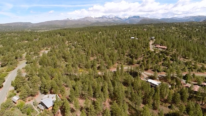
(This is where Durango Bill lives)
Durango Bill’s
Durango History via Topo Maps
The maps below give historical snapshots of Durango, CO. The featured areas extend northward to include Animas City and westward to include the Rafter J subdivision.
Durango, CO was established in 1880 by the Denver & Rio Grande Railroad. Animas City was founded 4 years earlier, but the D&RG Railroad created Durango as a base location for the mining districts after Animas City demanded a dowry to set up operations in Animas City. The railroad refused to pay the dowry/ransom, and Animas City was eventually annexed by Durango in 1948. See http://www.durango.org/press-room/fact-sheets/historic-walking-tour-facts for more information.
In the last few decades, subdivisions have been built in suburban areas outside the city limits. The author lives in the “Rafter J” subdivision WSW of Durango. Thus, addition information is given about the RJ subdivision. ( See http://rafterjhoa.blogspot.com/p/rafter-j-history.html for more information on the history of Rafter J.)
Map Sources
Most of the maps below were surveyed and printed by the U. S. Geological Survey. Free online access and/or full printed versions of the map segments shown here can be found at the USGS store at https://store.usgs.gov/b2c_usgs/b2c/start/(xcm=r3standardpitrex_prd)/.do
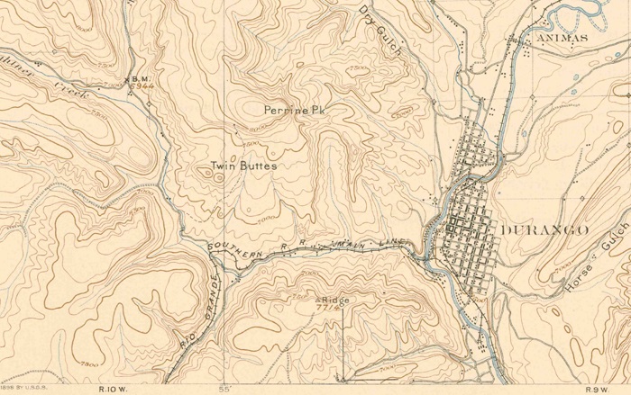
1898 Map
The first available USGS map of the Durango area was published in 1898.
(Click on map to see a larger map )
The street system in Durango was laid out by the Denver and Rio Grande Railroad. Animas City is a separate entity and is located 2 miles NNE of Durango. The Rio Grande Southern R. R. was a subsidiary of the D&RG; and it built a narrow gauge track system to access coal mines (for the smelter), and the gold and silver mines in the San Juan Mountains further north. One branch of the RGS R.R. tracks was located in Wildcat Canyon 3 miles WSW of Durango.
Some 60 years after the map date, U. S. Highway 160 will be built heading west out of Durango. From 2 miles west of Durango the future highway will leave the old railroad tracks and turn NW just to the left and below “Twin Buttes”, and then continue westward next to the winding stream that goes off the left edge of the map. However, as of 1898, there was only a primitive wagon road in this area, and it didn’t go very far.
The future Rafter J subdivision will be built in the lower left corner of the map to the left of the “Rio Grande” label. There is a small north to south drainage stream shown in the extreme lower left corner of the map. This is the future location of Meadow Road (County Rt. 142) which is the main access route to the Rafter J subdivision.
A small primitive dirt is also visible in the lower left corner. None of the current roads in the Rafter J subdivision use this road, but traces of the old road can still be seen to the north of Spring Road and to the west of Meadow Road.
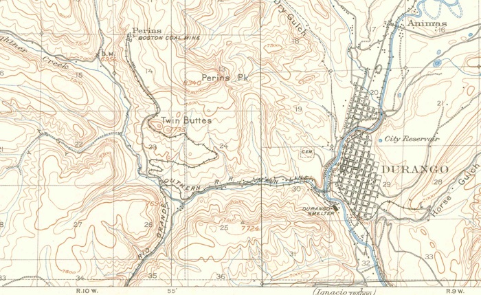
1907 Map
(Click on map to see a larger map )
By 1907 the Durango Smelter had been built across the river to the southwest of Durango. Silver and gold ores were brought down to Durango where they could be refined by the smelter.
Coal was needed to refine the ores. Durango was where the coal was, so that basically defined the optimal location for the smelter. One of the major coal sources was the “Boston Coal Mine”. The small community of Perins was built (3 miles WNW of Durango) where the miners could live without having to commute from Durango. A branch of the railroad was also built to haul coal to the smelter.
Other coal mines would also be developed in Wildcat Canyon (3 miles WSW of Durango). While Durango had grown in the preceding 9 years, Animas City was stagnating, and it would be another 70 years before anything of consequence would happen in the future Rafter J subdivision.
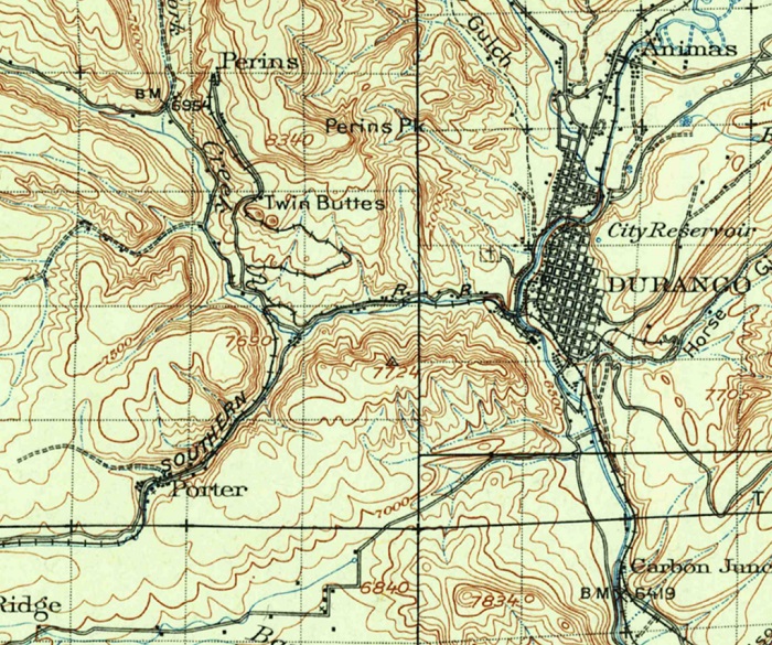
1924 Map
(Click on map to see a larger map )
There wasn’t a whole lot of change from the 1907 map to the 1924 map. The smelter was still operating even though it wasn’t labeled on the map. Animas City still existed, but hadn’t changed much.
To the WSW of Durango, the small community of Porter had sprung up to house workers for the Porter and other coal mines in Wildcat Canyon. Smelter operations were the lifeblood of the town, and coal was needed to run the smelter. (See https://www.fortlewis.edu/finding_aids/inventory/PORTERCOLNV.HTML for addition information on these coal companies.)
Further to the WSW (check the large map) another small community (Pine Ridge) had sprung up. There is very little left of the original Pine Ridge, but the upscale Shenandoah subdivision is just to the west and northwest of the former community of Pine Ridge.
Similarly, Porter would fold up and disappear after the Porter Mine ceased operations in 1917. There are remnants of the old coal operations in Wildcat Canyon, but the former town site is now just an open field.
The Boston Mine in Perins shut down in 1926.
The iron and steel rails used for the railroad tracks to the west of Durango are also gone. Any source of scrap iron and steel was used to make weapons for World War II, and the old rails were ripe pickings. The roadbeds for the old train routes are still quite visible – especially in the southwest end of Wildcat Canyon.
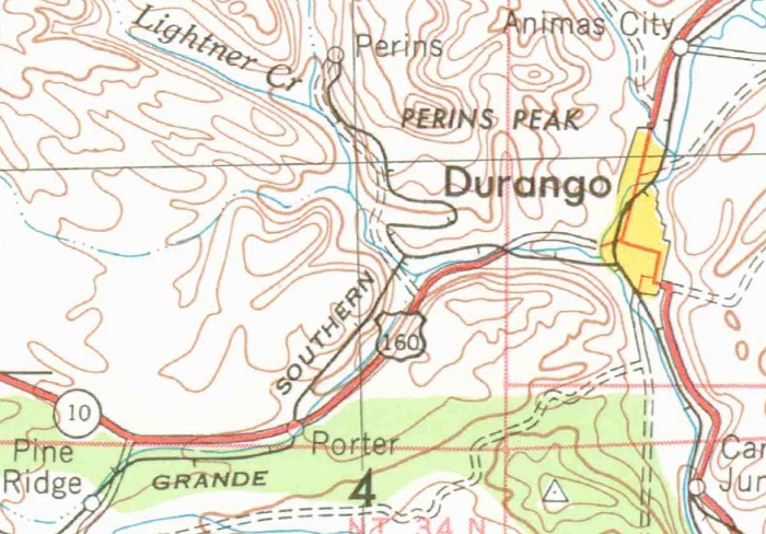
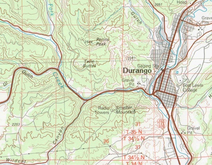
1953 Map
(Click on map to see a larger map )
The 1953 map is a small segment from a larger map prepared by the Army Map Service, Corps of Engineers. By 1953 coal mining and the smelter were history. (Except for another coal mine well off the map area that services the tourist oriented Durango and Silverton Narrow Gauge RR.) Durango was taking on its modern characteristics as a tourist area.
The road in Wildcat Canyon was paved and marked as U. S. Highway 160. However the present U. S. Highway 160 had not been built yet. There was still no development in the Rafter J subdivision as it was still part of the Rafter J Open A ranch.
The railroad lines to the west of Durango were still marked on the map, but they had long since been abandoned.
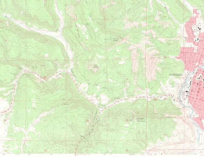
1963 Maps
(Click on map to see a larger map )
The map above shows the area to the east of Durango.
(Click on map to see a larger map )
The map above shows the area to the west of Durango.
The 1963 maps are presented in 2 sections since the USGS printed more detailed maps, and the dividing line for the maps ran right through Durango. The major new addition was the construction of the modern U. S. Route 160 to the west of town.
What is now the Rafter J Subdivision is showing its first signs of activity. The subdivision is on the ridges to the left of the Wildcat Canyon Road (near the bottom edge in the west Durango map). As of 1963 the subdivision area was still part of the Rafter J Open A ranch, but the owners of the ranch were beginning to sell off pieces of the ranch.
On the map there is a primitive dirt road that enters from the bottom edge near the left corner. This will become Meadow Road. (County Road 142). Another primitive dirt road branches off to the right of “Meadow Road” and continues along the top of the ridge. This will become “Ridge Road”. Finally, another primitive dirt road branches to the right off of “Ridge Road” and continues to near the bottom edge. This will become Saw Mill Road.
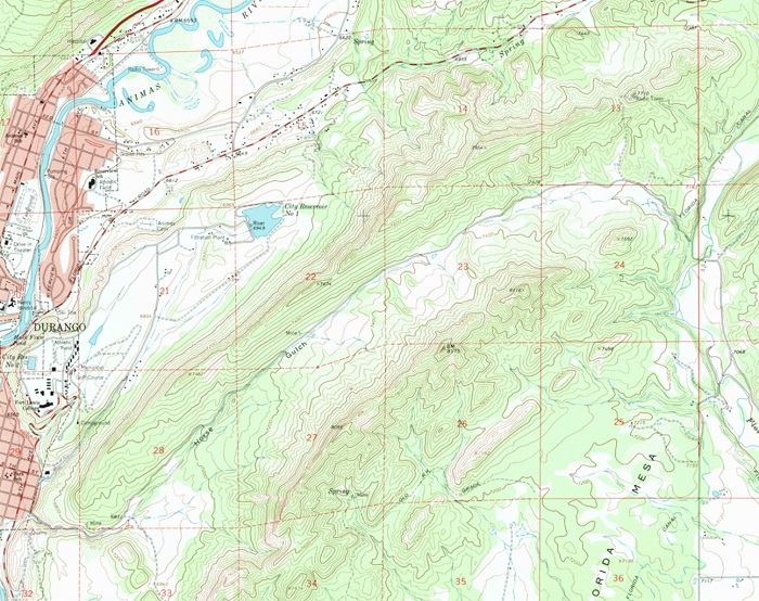
1983 Map
(Click on map to see a larger map )
The final map shown above was printed in 1983. (Note that elevations on the map are given in meters above sea level.)
The Rafter J Subdivision is now in business. Ridge, Saw Mill, Pinon, and Gulch Roads should be recognizable by local residents. Of note, the map shows a connection between Pinon and Gulch Roads. That connection has since been abandoned, but traces of the old road remain.
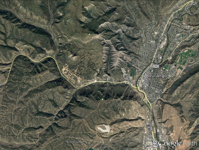
2015 Google Earth
View
(Click on map to see a larger picture )
The picture above is a 2015 Google Earth view with Durango to the right of center, the old Animas City location near the upper right corner, and the Rafter J subdivision in the lower left quadrant.
2015 Aerial view
from the Rafter J Subdivision
(Click on image to see a larger photograph)
The photo above was taken on May 27, 2015 from an elevation of some 250 feet above Saw Mill Road in the Rafter J Subdivision, and looks NNW toward the La Plata Mtns. The author’s home is in the lower left corner.
Return to Durango Bill's Home Page
Web page generated via Sea Monkey's Composer HTML editor
within a Linux Cinnamon Mint 18 operating system.
(Goodbye Microsoft)
